Downeast’s Newest Waterfront Gem Opens to the Public
Cobscook Shores, a ten mile stretch of parklands from Whiting to Lubec created by a philanthropic foundation, aims to provide an alternative to Acadia National Park for adventures by land and sea.

Downeast’s Newest Waterfront Gem Opens to the Public
Cobscook Shores, a ten mile stretch of parklands created by a philanthropic foundation, aims to provide an alternative to Acadia National Park for adventures by land and sea.
Photography by Peter Frank Edwards
by Sandy Lang
Issue: July 2021
Stand on a particular “double echo” overlook at Race Point, and you don’t even have to yell. Simply call out, a little above normal speaking volume, and returns of “hello, hello, hello” overlap in the air, seeming to float in from distant sources. We test the echoes while watching the powerful pull of tides between Dennys Bay and Straight Bay, which can rise and fall one foot every 15 minutes here in the Cobscook Bay region of Washington County. The water below is swirling and sliding past in at least two directions, and a series of eddies are whirling.
Just like that, we’ve found another wonder.
Sights and sounds are crisscrossing on our self-guided, unofficial treasure hunt in this easternmost county that borders Canada. We are on a quest for remarkable views and natural features in Cobscook Shores, a collection of waterfront parklands that officially opened to the public this summer in the ten-mile stretch between the towns of Whiting and Lubec.
Cobscook Shores is the second large-scale project undertaken in Maine by the Butler Conservation Fund, a New York–based charitable family foundation led by outdoorsman and philanthropist Gilbert Butler, who spent childhood summers with his family in Northeast Harbor on Mount Desert Island and still has ties there.

In 2019 the foundation opened Penobscot River Trails, a 4,300-acre tract on the East Branch of the Penobscot River with boats, warming huts, and more than 15 miles of carriage-style trails for bicycling, hiking, and cross-country skiing.
My travel cohort, photographer Peter Frank Edwards, and I have loaded the car with camping gear, bikes on the back, and a canoe on top. (The canoe is for freshwater paddling, not those rushing tides.) We see the first signage for Cobscook Shores on Route 189, heading toward Lubec—the name spelled out in tumbling letters, in a sort of 1970s disco font—before reaching Race Point.
After a two-hour drive from the midcoast, it’s good to stop the car in this all-the-way-downeast destination of coves and islands, bridges and massive tides, where there’s already a strong history of conservation, and landscapes are largely uninterrupted by development. Nearby parks on the mainland and islands are managed by federal and state agencies, along with organizations that include the Nature Conservancy, Downeast Coastal Conservancy, and Maine Coast Heritage Trust. Cobscook Shores adds to these layers of conservation and recreation possibilities in the region. The $11 million investment—so far—is designed to encourage hiking, picnicking, kayaking, bicycling between the properties, and “quiet enjoyment of nature,” according to the parkland maps and website. We’re ready to get out there.

One of the picnic shelters at Race Point. The ocean scene from the Race Point parkland. 
The newly opened Cobscook Shores includes information kiosks, miles of waterfront and trails, restroom facilities, and screened picnic shelters.

Picnic Ready
At Race Point we first see a couple of the one-room screened buildings, each with a table and chairs inside. One screen house offers a long view across a meadow and another is more tucked away, perched on a wooded, bayside pathway with overlook views. “We like to surprise people with them,” Carl Carlson, director of parklands and environmental philanthropy for the Butler Conservation Fund, later tells me. These handsome wooden picnic pavilions with peaked roof-tops and brass hardware are among the signature features of Cobscook Shores. “They’re a great option to pull people in and induce them to take a hike,” Carson says. “If we put them at the entrance, people would stop right there. We site them a little way in, each with a vantage point that’s different and special.”
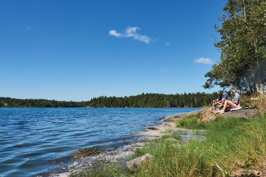
We see two couples arrive and walk toward one of the pavilions with paper bag lunches. They say hello and tell us they all live about 30 miles away and are visiting for the second time in a week. “We love these places,” one of the women says. “Someone had a real vision.”
Hungry, too, we pedal our bikes partway along the gravel trails and then follow a path to where the reversing tides are creating a froth and turmoil on the water’s surface. On a ledge at the water’s edge, we make our own picnic with salad greens and noodles. Meanwhile, we have a front-row view of the water-frenzy of the reversing falls, which a local woman we met earlier on the trail said can “sound like a jet engine when it’s really going.” The volume is remarkable for a while. Eventually, when the water calms to relative smoothness, a fishing boat motors through, the captain obviously well versed in timing his passage before the swift return of the rushing tide waters.
Bayside Beach to Campsite Near
Next stop is a park along Whiting Bay where a short trail leads to a beach of flinty stones—each footstep along a curving cove makes a crunching sound. Across the water in the distance, I see the boat landing at Cobscook Bay State Park, and we sit on our unfurled jackets for a while in the sunshine. Two plovers are in the foam edge on the shoreline as waves lap, and then, 50 yards or so out in the water, a seal pops up, his head looking much larger than a harbor seal’s. It must be one of the gray seals, nicknamed horseheads. A couple of summers ago, I first learned of them on a whale watching cruise from Bar Harbor. Seems we’ve happened upon another treasure.
It’s getting to be time to set up camp. Since the array of protected lands in Washington County allows easy passage between state, federal, and local parks and properties, it’s only about ten miles by car to get to the state park we’ve just seen. Cobscook Bay State Park is home to a beautiful campground that we’ve visited before, and our campsite this time overlooks a small cove.


It’s a terrific spot to watch the sun through tall trees and to observe the tide change. We set up a couple of folding chairs, and Peter Frank has even brought an old turntable to arrange on one end of the picnic table and plug into a battery pack he uses for photography. The sound is tinny, and it’s a worn needle, but we have some old LPs of orchestra performances that sound just right rising through the trees in the afternoon. An omnipresent campground squirrel moves in closer, as if the soft music is a draw. And when the water recedes, leaving a mudflat, we watch sandpipers skittering on the mud and two children digging up clams to collect in a bucket. (A sign at the campground entrance notes that campers are allowed to harvest one peck per person, if no red tide warnings are posted.)
After dark we hear owls hooting, then sometime after midnight I wake up in the tent to a not-too-distant outburst of yipping and yelps that must be a coyote with pups. This area around Cobscook Bay is about 240 miles northeast of Portland, and the remote wildness is always present, including in the night sky, with barely an open space among the multitude of stars.


Rivers and Coves
The next morning, we drive to a landing with access to the Orange River. Maps of Cobscook Shores show several saltwater trail options for experienced sea kayakers, but our canoe is just right for this freshwater stop. We slide it in on a sheltered creek in the marsh and quickly come to the first of the six beaver dens we’ll see over the two hours paddling the canoe—one mound of branches and mud is nearly as big as a human house. We hear a barking dog in the distance but see no other people, and the wildlife is plentiful. In the puffy-cloud, blue-sky morning, we observe an osprey, blue heron, ducks, kestrels, turtles, pickerel, and schools of minnows.
The natural treasures continue when we move on to Pike Lands Cove. This property features a legacy collection of trees, many planted decades ago. Walking through the grove, we smell the scents of sweet apples, cedar trees, and meadow wildflowers. Through the woods is a split-log trail to the cove and then a sweeping view from a gravel beach on a point jutting into Cobscook Bay.


The incoming tide here races past a buoy with a rushing sound that reminds me of an espresso machine. The water is so powerful here. Flotsam as big as a moose jets by at one point—in fact, we think it is a moose until it’s close enough for us to discern that it’s a log tangled in something. We step carefully, at first, past plants with tiny purple flowers. But soon we pick up the pace, hurrying back the way we came before the seawater can wash over the path, which is already becoming soggy. The final few steps to higher ground are splashes.
Here’s the Point
After one more camping overnight, we finish where many visitors begin their exploring of Cobscook Shores. At Old Farm Point, the land rises from a meadow to a tall bluff with views of Lubec, and a dramatic black gravel beach below. With an eagle calling somewhere overhead, I sit on a bench until the rain starts. The weather doesn’t diminish the peaceful morning, and along the walk back, I see an eagle feather on the ground. More treasure.
From here you can be among the first in the nation to see the sun’s light each morning, and the Canadian Maritimes are often in view. It’s always such a remote, edge-of-the-world feeling for me, to be in these most easterly points in Maine.
Plus, now I know that this is where double echoes are possible too.


EXPLORING COBSCOOK SHORES
With an official grand opening this summer, Cobscook Shores offers new vantage points around the south side of Cobscook Bay from Whiting to Lubec.
The 14 properties along some 14 miles of shorefront in Washington County aren’t contiguous. “We see them as a collection of parklands—dispersed but one system,” says Carl Carlson, director of parklands and environmental philanthropy for the Butler Conservation Fund, which established this network of private lands that feature public access. “Arrive to one and then bike to others. There are bicycle racks at each.”
Carlson says Cobscook Shores is still growing, with more trails and properties envisioned and on tap for the future. Already, features throughout include paths and trails for hiking or bicycling, picnic sites, and restrooms. Some trails lead to screened picnic pavilions, gravel beaches, or hand-carry boat landings—along with plenty of woodland and water views. There are kiosks and new signage on local roadways and at each property. Five hike-in campsites are also available at the Huckins Beach property. (No reservations; availability is first-come only.)
Visitors can find more information and maps to the trailheads and parking areas at cobscookshores.org.
Share The Inspiration
