Scenic Drives
May 2015
By: Kelly Clinton
Photography: Peter Frank Edwards
Fred Michaud, scenic byways coordinator for the Maine Department of Transportation, explains to be called a byway, routes have to be scenic, of course, but also have to have cultural, historic, natural, recreational, and archeological significance. Maine has 14, of which four are nationally recognized, and one has an “All-American” designation.
01 Moosehead Lake Scenic
Byway | Maine Highlands
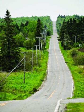
Maine’s largest lake is almost 40 miles long and has dozens of wild islands. A 67-mile-long scenic byway passes by the body of water that fuels the Kennebec River. The route can begin in Jackman. It winds along the waterway and dips toward the lake in Rockwood (here pull in to the parking lot for views of Mount Kineo). The road continues on to Greenville, a town with stores, museums, and the Katahdin, which gives tours around the lake, and passes through Lily Bay State Park, a family-friendly campground on the shore of the lake. The
trip ends in Kokadjo, a winter sports village considered the gateway to the North Maine woods.
02 OldCanadaRoadNational Scenic Byway | Kennebec and
Moose River Valley
Starting in Canada, this 78-mile route gets
its name from the immigration of French Canadian families to find work in Maine’s milltowns, such as Skowhegan and Waterville. Today the route can be an active adventure: stop in Jackman and go on a canoe adventure on Attean and Holeb Ponds. Then head south and spend time in the Forks to go whitewater rafting in an area that has seen a surge in the sport. Along the way make the trek to Moxie Falls, one of the largest vertical waterfalls in the state. The route runs through the town centers of Jackman, Bingham, and Solon.
03 Rangeley Lakes National Scenic Byway | Maine Lakes and
Mountains
When it comes to scenic byways in the state, this one has recreation and spectacular scenery. Starting in Rumford and moving north through Mexico and Byron, this national scenic byway calls for a leisurely pace as it passes Coos Canyon and Angel Falls, and runs twice through the Appalachian Trail. Drivers can take their time, stopping for hikes or boat rides on the waterways. The road runs parallel to Mooselookmeguntic Lake where the Appalachian Mountains, some with peaks over 4,000 feet tall, are the backdrop to gorgeous placid waters. The route then wraps around Rangeley Lake. Watch for moose on this 52-mile journey.
04 Acadia All-American Road
| Downeast and Acadia
Of the 150 national scenic byways, 30 are designated as “All-American,” meaning the road is significant in a number of ways. Acadia Road, being historical, cultural, recreational, and scenic, is one of those routes. Acadia National Park receives international attention for its landscape, carriage paths that run through the woods, and the Park Loop Road that passes Cadillac Mountain. This national route is 40 miles long and traces the edge of the island, traveling around coves and inlets through Northeast Harbor and Bar Harbor.
05 Million Dollar View Byway (Route 1) | Aroostook and
Downeast
A short eight-mile drive, but one that is worthy of its name, Million Dollar View Byway is a straight shot up Route 1 past Chiputneticook Lakes. Through the remote landscape look out the window to see Mount Katahdin, views of New Brunswick across the border, and potentially wildlife, including bears, deer, eagles, and moose. The route climbs Peekaboo Mountain and at the top are elevated views of the lakes and forests.
06 Bold Coast Scenic Byway |
Downeast and Acadia
Travel through the untamed beauty of downeast Maine on the Bold Coast Scenic Byway, which is a motorcyclist’s dream. The route follows the coastline from Milbridge
to Lubec for 125 miles. Pass through small fishing villages and by iconic lighthouses and unspoiled scenery that will have travelers pulling over to take photographs whenever possible. Also along the way, drivers will make their way through wildlife refuges such as Petit Manan and Moosehorn, state parks Quoddy Head and Roque Bluffs, and Cutler Coast Public Reserved Land. Stop by any of these protected refuges and take a walk through quiet woods and along the shore for uninterrupted views that stretch across the sea.
07 Schoodic National Scenic
Byway | Downeast and Acadia Schoodic National Scenic Byway is a quieter route than its Mount Desert Island neighbor. The road starts in Hancock, following the rough coast past Sullivan Harbor, Flanders Bay, and islands off shore. This is where wooden piers jut into the water and lobster boats are moored in protected coves. The byway enters Winter Harbor, where there is a strong artist community. Views include Mark Island Lighthouse, Ned and Turtle Islands, and the mountains of Acadia.
08 Katahdin Woods and Waters Scenic Byway | Maine
Highlands
Katahdin Woods and Waters Scenic Byway is a place for wildlife watching as it wraps around Baxter State Park and has views of Maine’s highest peak. The route starts in Millinocket and cuts through forest and land that feels secluded and largely undiscovered. There are many points to stop off for recreational activities, such as back trails for biking and hiking and old logging roads that, in the winter, are groomed for cross-country skiers and snowmobilers. Take a rest stop at New England Outdoor Center in Millinocket for food and information.
09 St. John Valley Cultural
Byway | Aroostook
In the eighteenth century the people of Acadia were expelled from what is today Nova Scotia and they settled in the St. John Valley at the top of Maine in towns like Madawaska, Frenchville, and St. Agatha. This region still holds on to its historical and cultural values— many people speak both French and English and fly the Acadian flag outside shops and homes. Driving along this road, which is 100 miles long, New Brunswick is right across the St. John River. In the summer the rolling hills are green and spill into the rushing blue waterway.